French country side has proved to be very interesting. I was following Eurovelo 3 (along the river of Seine), then little bit of Eurovelo 6 (along the river of Loire).
All this was never boring to me and offered very quiet athmosfere to cycle, free of other vehicles. Also wild camping was very easy on most of these parts since it was following only cycle paths. That assumes of course you are comfortable with wild comping in plain sight (as I call it). Its no so much hiding when you camp but more respectful open your tent after dark and wake up early(er). For me, this usually means 23-07.
Since my route took me towards Torino, at one point I stopped following Eurovelo and Komoot guided me towards the alps on the way to Italy.

One day I found myself on the landscapes which look very similar to what I have experiences in Italy on my previous trips.
The path was following the river of Rhone and there were lot of hills with grapes.


Camping in the woods next to the town of Chalamont.


The area suddenly become all rocky making me think how many climbing areas must be around here.

I actually took a swim (more of a wash) in this river and this suited me a lot, because I havent showered since leaving Paris (which wasnt that long ago, but still took a toll one me).
The river was kind of green looking and I think rather clean but the coast of the river was this mud which you had to scramble to get in and out of the river.
So I was using flip flops to try to get out of the river and avoid too much mud on my feet and in the socks.
But the river was well worth it.


French arhitecture

Groslée Suspension Bridge. Beautiful bridge across the Rhône river, between Groslée and Brangues.

Very quiet area next to river Rhone with cycling paths only. it would be a dream to sleep here somewhere..

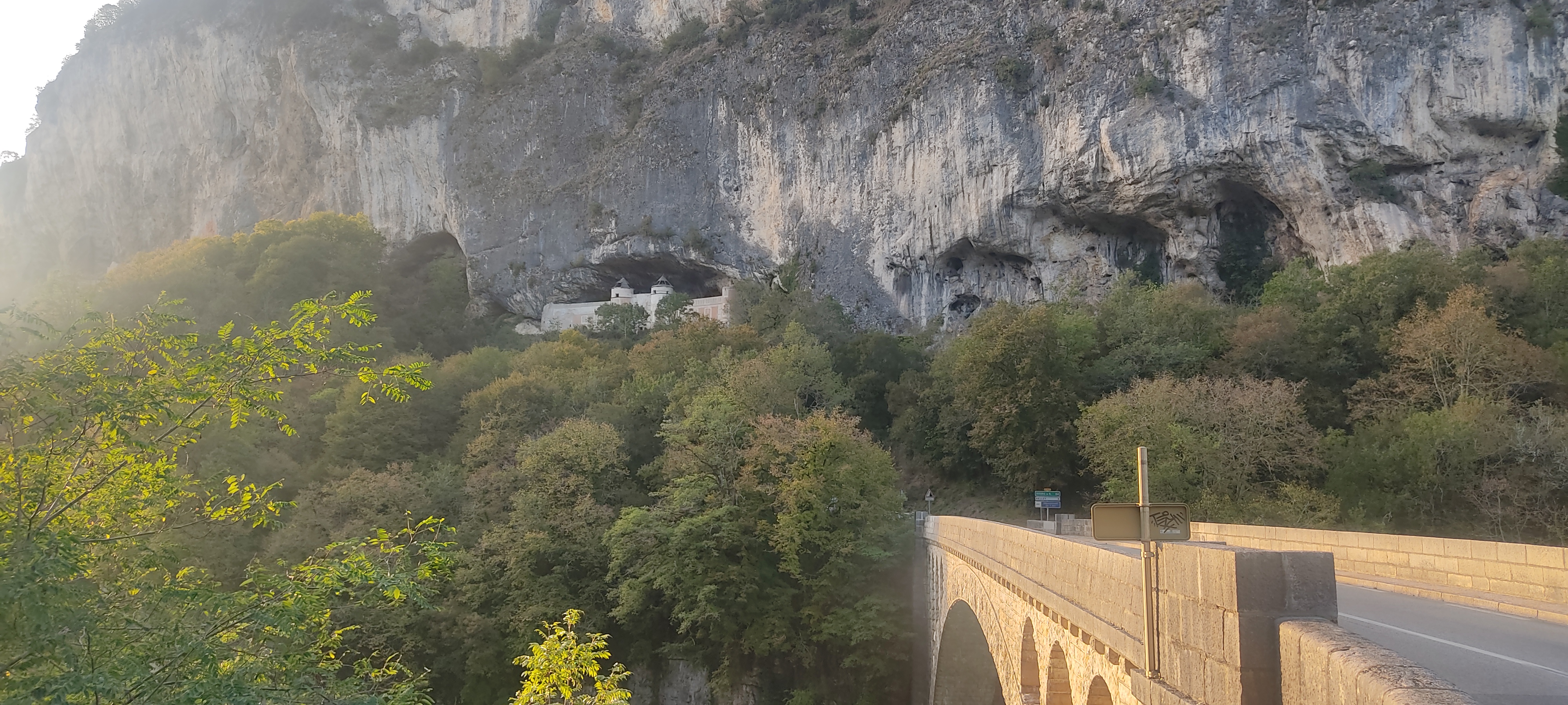
Passing through the canyon and the cliffs of Gorges de la Balme. This part was very beautiful but also very busy with vehicles.

The 1500 meter long cycling tunnel Tunnel du Chat (going through Mont du Chat) and connects Savoyard Avant-Pays to the west and the Cluse de Chambéry to the east.
I ended there one night and I was struggling a bit to find a place to sleep that night.
After leaving the small town of Yenne (located on the east side of the Rhone, by the Gorges de la Balme) I continued to cycle upwards, I decided to go on the other side through the tunnel hoping on the other side would be better places for camping.

But other side of the tunnel actually proved to be worse with just a parking lot where cars could access and some hiking trails not suitable for camping and full of people leaving shit papers (which I fricking hate and who does not?).
Then I decided to cycle back through the tunnel because it was little bit more suitable on the other side but only just.
All this took me way into the night.
I end up sleeping next to this building alongside the tunnel which I guess is used for tunnel maitainance and inner workings.

Next morning the view over Lac du Bourget. This is where the tunnel exits on the other side. Looks very nice but its also very busy with traffic.


Next day after cycling though town of Chambéry and following the valley towards Mont-Cenis Pass over the alps I had some nasty roads on which you had to cycle with a lot of traffic and a lot of these constructions sites escavating the surrounding rock and trucks driving around.

Luckily at the end of the day I managed to find perfect camping spot next to one of these water facilities with a view over the city of La Chambre.
Slept nicely that night with loud sound of water running.

Inevitable sleeping gear drying in the middle of the day in the sun.

Victor Emmanuel fort, an impressive fort which raises next to the road.

In fact, there were other similar buildings like these in this valley. If I was not loaded with all this gear, I would definitely went on exploring the road which leads to this fortress.

The town of Val Cennis, an alpine ski resort. After this the climbing begins. But this town is already at around 1300m of elevation so there is not a lot of climbing to the top of this pass Mont Cenis.

The trip contined next day through the valley towards the Mont-Cenis Pass.
I decided to end the day early and stayed next to the river, which was easily accessible next to the road.
This was just before the town of Val Cennis after which the climbing over the pass starts.

Of course inevitable washing with soap in the super cold river in the evening and in the morning was bound to happen.

Cosy dinner with my favorite food, frozen vegetables which I quickly prepare in boiling water.


The next day was the day I went over the pass - and onto Italy.

The town of Val Cennis, an alpine ski resort. After this the climbing begins. But this town is already at around 1300m of elevation so there is not a lot of climbing to the top of this pass Mont Cenis.


Except from this one peak, I did not see any other snow covered peaks when going over this mountain pass. This a could be view towards Dent Parrachée, but I am just wild quessing based on orientation.


This pass was very beautiful, even more because being beginning of October, there was almost no traffic at all at the top.


The lake view from the top of the road reminded me a little bit of Norway. There were some camper vans parked below next to the lake.
The lake looked clear at least on the shallow parts next to the coast. There were also gravel roads leading around the lake and into the surrounding mountains.

I immediatelly got the wish to sleep in this surroundings. Of course this would not be possible without the warm 3 season sleeping bag which I do not have with me on this trip. This lake sits at 2000m of elevation so the nights are very cold.

Descend on the other side into Italy was nearly not as nice as French side and the views it offered!

Misty Italy, almost looks like pollution.

No comments:
Post a Comment